What Qualifies a Tree as a “Hazardous Tree” Under Auburn City Regulations?
Under City of Auburn regulations and Pacific Northwest arboricultural standards, a tree qualifies as hazardous only when it possesses both a verifiable structural defect making failure likely and a designated target—such as a permanent building, public roadway, or active utility line—within its striking distance. A certified arborist must document these defects in a formal Tree Risk Assessment Qualification (TRAQ) evaluation rating the tree as a high or extreme risk to bypass normal clearing caps or emergency critical area restrictions.
The Legal Formula: Defect Plus Target
Municipal code and professional arborists separate a decaying tree from a legal hazard using a clear formula:
Structural Defect + Viable Target = Hazard Tree
A dead, hollow Douglas fir standing in the center of an open five-acre wetland tract possesses severe defects, but it has no target. Under Auburn regulations, that tree is classified as beneficial wildlife habitat (a snag), not a hazard.
Conversely, a living big-leaf maple with hidden internal rot located 15 feet from an occupied bedroom on Lea Hill or hanging over the sidewalk on Auburn Way possesses both a high probability of failure and a high-value target. That combination qualifies it as an actionable hazard under city guidelines.
The 6 Structural Defects Recognized in Municipal Evaluations
Auburn code officials and ISA Certified Arborists assess six physical defect categories when evaluating trees for emergency removal or critical area hazard exemptions:
1. Root Plate Failure and Soil Heaving
The root plate provides the mechanical anchorage counteracting wind shear. Saturated soils during Western Washington winters weaken this foundation. Signs of imminent root failure include:
- Freshly mounded soil or cracked earth on the side opposite an unnatural lean.
- Exposed, snapped lateral roots along the root collar.
- Standing water pooling beneath an actively shifting root flare.
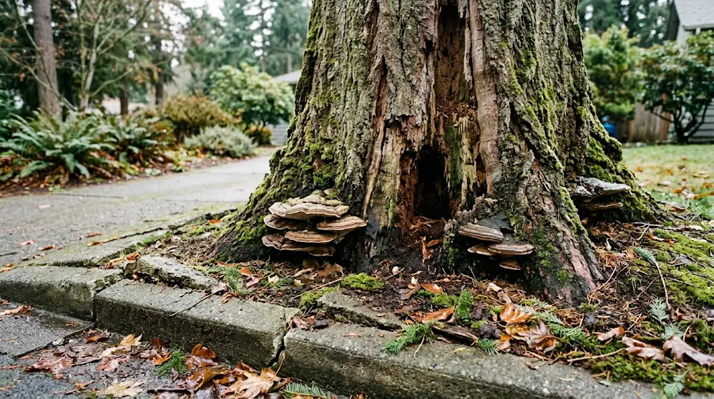
2. Wood-Decay Fungi and Basal Conks
Fruiting bodies (conks, mushrooms, or brackets) growing on the lower trunk or root flare indicate advanced internal sapwood or heartwood rot. Native Auburn species frequently succumb to specific decay fungi:
- Laminated Root Rot (Phellinus weirii): Decays Douglas fir roots, causing green trees to snap clean at ground level without warning.
- Velvet-Top Fungus (Phaeolus schweinitzii): Attacks the butt and lower trunk of mature conifers, degrading structural tensile strength.
- Artist’s Conk (Ganoderma applanatum): Common on stressed big-leaf maples, indicating hollow central wood.
3. Co-Dominant Stems with Included Bark
Trees that fork into two or more main trunks of similar diameter often develop “included bark.” Instead of continuous wood fibers binding the trunks, bark pinches inward between the stems, creating a structural wedge. During heavy windstorms or snow loads, this junction splits down the center.
4. Severe Lean and Tension Cracks
A tree that grew with a natural sweep toward sunlight is not necessarily hazardous. A tree that develops a sudden, corrected lean—especially greater than 15 degrees from vertical—indicates ground-level root plate shearing. Horizontal bark ruptures or longitudinal cracks along the tension side of the trunk signal structural wood failure.
5. Cavities, Cankers, and Shell Wall Depletion
Trunk hollows caused by past limb breakage or disease reduce the tree’s load-bearing capacity. Under ISA standards, a tree enters the hazard threshold when its healthy outer wood shell drops below 30% to 35% of the total trunk diameter at the defect point.
6. Canopy Dieback and Suspended Limbs (“Widow-Makers”)
Large, broken branches lodged in the canopy represent immediate falling hazards. Widespread crown dieback in deciduous species like red alder indicates vascular death, leading to rapid limb drop over driveways, structures, and walkways.
Auburn Hazard Tree Evaluation Matrix
| Structural Defect | Visual Indicators | Failure Mechanism | Typical Auburn Species Affected | Risk Level Under TRAQ |
| Root Plate Shear | Soil mounding, fresh surface fissures, lifted turf | Whole-tree uprooting during high-wind events | Douglas fir, Western red cedar | Extreme |
| Basal Heartwood Rot | Hard conks at ground level, hollow trunk resonance | Trunk shear or butt snap near grade | Douglas fir, Western hemlock | High to Extreme |
| Included Bark Crotch | Deep V-crotch with pinched inward seams | Splitting down central junction under wind/ice loads | Big-leaf maple, red alder | High |
| Trunk Canker / Cavity | Open cavities, missing bark, oozing sap wounds | Buckling along structural stem wall under canopy weight | Cottonwood, big-leaf maple | Moderate to High |
| Dead Crown / Dieback | Leafless upper canopy, brittle grey branches | Progressive branch shedding (“widow-makers”) | Red alder, paper birch | Moderate to High |
| Corrected Lean (>15°) | Fresh lean angle, soil lifting on opposite side | Total structural collapse | Douglas fir, Western hemlock | Extreme |
Critical Area Regulations: ACC Chapter 16.10
On standard private residential lots, Auburn Tree Maintenance and Removal guidelines permit homeowners to remove up to 6 trees per acre within a rolling 12-month period without a municipal permit.
However, when a tree sits inside an environmentally sensitive zone, normal exemptions disappear. Under ACC Chapter 16.10 (Critical Areas), Auburn strictly regulates:
- Geologic Hazard Areas (steep slopes exceeding 15% to 40% on Lea Hill and West Hill bluffs)
- Streams and riparian corridors (Green River, White River, Mill Creek)
- Wetlands and mandatory protective buffers
How to Legally Remove a Hazard Tree in a Critical Area
You cannot cut a tree in an Auburn critical area simply because it is inconvenient or blocks a view. To qualify for emergency or permitted hazard removal, you must execute three steps:
- Commission a Certified TRAQ Report: An ISA Certified Arborist with Tree Risk Assessment Qualification must inspect the tree, complete an ISA Tree Risk Assessment form, and rate the residual risk to permanent targets.
- Prioritize Snag Creation: Whenever feasible, city regulations favor creating a 10- to 15-foot wildlife habitat snag over complete ground-level flush cutting to maintain soil stabilization on slopes.
- Emergency Notice Window: If the tree presents an imminent life-safety threat, the owner may fell the hazard immediately. The property owner must submit the arborist report, photographic evidence, and an emergency notification to the Auburn Planning Department (planning@auburnwa.gov / 253-931-3090) within 10 days of removal.
Public Right-of-Way and Nuisance Codes (ACC 12.36)
Trees bordering roads and walkways are subject to additional municipal safety standards. Under ACC Section 12.36, the city classifies vegetation as a public safety hazard if it violates dimensional clearances:
- Sidewalk Clearance: Low-hanging branches must maintain at least 8 vertical feet of clear headspace over public walkways.
- Roadway Clearance: Branches extending over public street travel lanes must maintain at least 14 vertical feet of vertical clearance for emergency vehicles, buses, and delivery trucks.
- Intersection Sight Triangles: Trees obstructing sightlines at street corners or driveway entrances violate city code and must be pruned or cleared.
Property owners abutting the public right-of-way are legally responsible for pruning street trees to maintain these clearances.
Local Proof: Auburn Weather and Soil Realities
Auburn’s geographic position makes local trees particularly vulnerable to structural failure:
- Saturated Glacial Soils: Auburn averages more than 40 inches of rain annually. Glacial till and sandy loam soils across Lea Hill become waterlogged between November and March, severely reducing the frictional holding capacity of shallow conifer root networks.
- Green River Wind Funneling: Cold air drafts through the Green River Valley push localized wind gusts of 45 to 60 mph through residential neighborhoods. These sustained gusts exert high rotational torque on tall, shallow-rooted conifers.
- Target Density: Dense suburban lot configurations across Auburn mean a mature 100-foot conifer almost always has multiple primary targets—including homes, garages, driveways, and overhead service lines—within its failure envelope.
5-Step Action Checklist for Documenting a Hazardous Tree in Auburn
- [ ] Identify the Target: Confirm that an occupied structure, driveway, sidewalk, or utility line falls within the tree’s height radius (plus a 1.5x buffer zone).
- [ ] Inspect the Root Flare: Check ground level for fungal conks, cracked earth, or fresh signs of heaving soil.
- [ ] Verify Property Zoning & Critical Areas: Check your parcel on the City of Auburn GIS viewer or call the Permit Center to confirm whether your parcel carries steep slope, stream, or wetland buffers.
- [ ] Schedule an ISA TRAQ Arborist: Hire a professional arborist certified through the International Society of Arboriculture holding explicit Tree Risk Assessment credentials. Verify active status via the Washington State L&I Verification Portal.
- [ ] File Proper Municipal Records: Retain the written arborist report. If the tree sits in a critical area, file the required paperwork with Auburn Planning Services prior to cutting, or within 10 days if handled as an active emergency.
If you suspect a tree on your property has structural rot, root failure, or storm defects, Auburn Tree Removal delivers certified hazard evaluations, municipal documentation, and precision rigging to safely eliminate structural risks. Visit our contact page to arrange an on-site hazard evaluation with an experienced local arborist.